Who We Are
Busia is a county in the former Western Province of Kenya. It borders Kakamega County to the east, Bungoma County to the north, Lake Victoria and Siaya County to the south and Uganda’s Busia District to the west. The county population was 893,861, as of 2019.[2] It spans about 1,700 square kilometers, making it one of the smallest counties in Kenya. Busia is inhabited by the Luhya tribe and the Teso of Kenya, and small groups of the Luo. The Luhya communities include the Abakhayo, Marachi, Samia and Abanyala communities.
Etymology
Busia county is part of Western Province of Kenya. It has been commonly inhabited by the Luhya tribe of Kenya the minority tribe of Iteso. Prior to being a county, it was known as Busia district before more districts were created by president Mwai Kibaki. Busia county borders Uganda to the west. The Samia people of Busia are the same community as those of Uganda Busia district. There has been an outcry for Samia people on why the colonial government decided to cut and separate them placing them in different countries.
Geography
Busia County borders Bungoma County to the north, Kakamega County to the east, Siaya County and Lake Victoria to the south east and south respectively. Busia with approximate of 1700 square kilometers is bordered to the south by Lake Victoria with some rivers pouring water into it. the rivers include River Nzoia in Budalangi and River Sio in Samia. There are several hills in Nambuku, Odiado Hills and Funyula. Several swamps are also located across the county with species such as crocodiles, hippos, and multiple types of fish. There are also some leopards and antelopes that are usually spotted across the county.

.
Lakes and rivers
- Lake Victoria
- River Sio
- River Malaba
- River Nzoia
- River Akanyo
Religion
Most residents are Christian with few Muslims and African believers.
Language
Economy
The main economic activities include farming and tourism.
Tourism
- Lake Victoria
- Kakapel Monument
- Samia Hills
- Kavirondo Rocks
- Yala Swamp
- Malaba Sanctuary
- River Nzoia
- Sio Siteki Swamp
Demographics
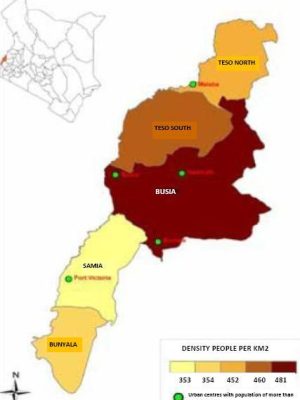
Busia county has a total population of 893,681 persons. Of this 426,252 are female, 467,401 are male, and 28 people were reported as intersex. The county has a population density of 527 persons with an average household size of 4.5 persons.
Administrative units
Busia County is made up of seven administrative sub-counties, thirty-five county ward assemblies, sixty locations and one hundred and eighty-one sub-locations.
Sub-Counties
Health
Busia County has a total of 81 health facilities, out of this 1 county referral hospital, 6 sub-county hospitals, 12 health centres, 49 dispensaries, 10 Medical Clinics, 6 Nursing Homes and 1 in the other categories.[12]
Common diseases in the county include Malaria, Respiratory Diseases, and diarrhoea.
Education
Busia county has a total of 735 pre-primary schools, 551 primary schools, 152 secondary schools.[3] As at 2014 the county had an enrolment 255,008 students in primary schools and 41,332 students in secondary schools.[14]
Alupe University College is the only public university in Busia County.[15][16]
Transport and infrastructure
Villages and settlements
- Bujwane
- Bukoma
- Bunyala
- Busike
- Chamasiri
- Chelelemuk
- Debani
- Eburemia
- Galafahi
- Idokho
- Bukhwamba
- Bukhulungu
- Kholokhongo
- Kwangamor
- Makhoma
- Mbuvu
- Namabusi
- Namboboto
- Namiaso
- Nangina
- Nyapera
- Tingolo
- Bukanga
- Mubwokhola
- Budebu
- Lwanya
- Bukati
- Sikarira
- Masendebale
- Mung’abo
- Sigulu
- Elukhari
- Apama
- Atapar
- Buteba
- Ojame
- Morototo
- Omoloi
- Gara
- Kamolo
Busia County
P.O Box: Private Bag 504100, Busia,
info@busiacounty.go.ke
Monday – Friday, 8:00 am – 5:00 pm

